 www.geodatenkatalog.de (S3F)
Keyword
bodenphysikalische Eigenschaften
74 record(s)
Provided by
Type of resources
Available actions
Topics
Keywords
Contact for the resource
Update frequencies
Service types
-
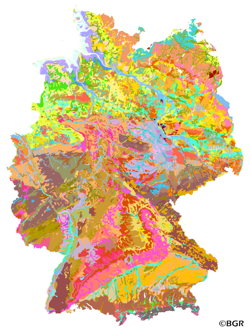
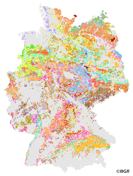
The first country wide soil map at a scale of 1:1,000,000 (BUEK1000) has been compiled on the basis of published soil maps of the former German Democratic Republic and the pre 1990 federal states of Germany. To do this, it was necessary to match the soil systems used in East and West Germany and to develop standardized descriptions of soil units. A relatively homogeneous map has resulted, which permits uniform assessment of the soils throughout Germany. The map shows 71 soil mapping units, described in the legend on the basis of the German and FAO soil systems. Each soil unit has been assigned a characteristic soil profile (Leitprofil) as an aid to map interpretation. For the first time the subdivision of the country into 12 soil regions has been represented on the map. This subdivision was coordinated with the state Geological Surveys. These soil regions will represent the highest hierarchic level of nation wide soil maps in future. The colours of soil units correspond to the standards of the 'Bodenkundliche Kartieranleitung' (KA 3; Guidelines for Soil Mapping). The various hues characterize differences in relief or soil humidity. The BUEK1000 was produced digitally. It is an important part of the spatial database integrated in the Soil Information System currently being established at the Federal Institute for Geosciences and Natural Resources (FISBo BGR). It can be used together with the characteristic soil profiles to derive thematic maps related to nation wide soil protection. The scale of the BUEK1000 makes it especially suitable for small scale evaluations at federal or EU level.
-
Web Map Service (WMS) of the BUEK1000. The first country wide soil map at a scale of 1:1,000,000 (BUEK1000) has been compiled on the basis of published soil maps of the former German Democratic Republic and the pre 1990 federal states of Germany. To do this, it was necessary to match the soil systems used in East and West Germany and to develop standardized descriptions of soil units. A relatively homogeneous map has resulted, which permits uniform assessment of the soils throughout Germany. The map shows 71 soil mapping units, described in the legend on the basis of the German and FAO soil systems. Each soil unit has been assigned a characteristic soil profile (Leitprofil) as an aid to map interpretation. For the first time the subdivision of the country into 12 soil regions has been represented on the map. This subdivision was coordinated with the state Geological Surveys. These soil regions will represent the highest hierarchic level of nation wide soil maps in future. The colours of soil units correspond to the standards of the 'Bodenkundliche Kartieranleitung' (KA 3; Guidelines for Soil Mapping). The various hues characterize differences in relief or soil humidity. The BUEK1000 was produced digitally. It is an important part of the spatial database integrated in the Soil Information System currently being established at the Federal Institute for Geosciences and Natural Resources (FISBo BGR). It can be used together with the characteristic soil profiles to derive thematic maps related to nation wide soil protection. The scale of the BUEK1000 makes it especially suitable for small scale evaluations at federal or EU level.
-
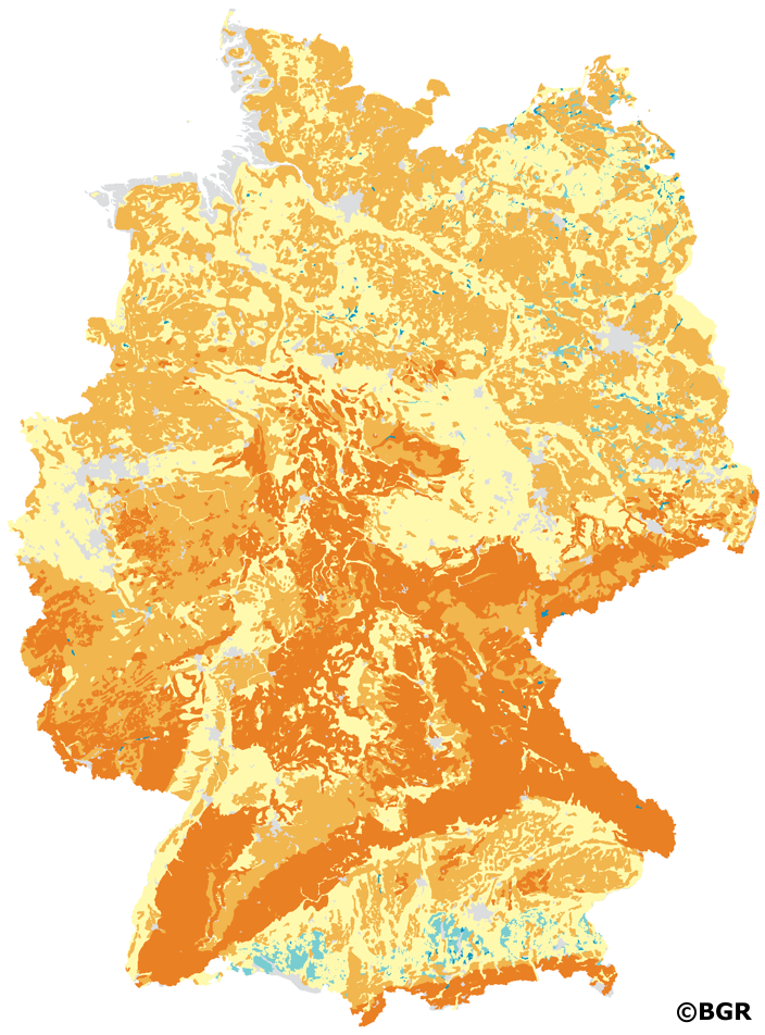
In addition to the natural soil functions, knowledge of the thermal properties of soils is an important parameter for the use of soils, e.g. for near-surface geothermal energy. The heat distribution is largely determined by how quickly the soil conducts energy in the form of heat. How strongly this happens is expressed in the property of thermal conductivity. The thermal conductivity is given in the unit W/(m*K). In addition to the material composition of soil, the water and air balance is decisive. For the present dataset, the soil profiles of the BUEK1000N were evaluated according to the soil science method documentation of the Soil Working Group AG Boden. The soil texture, the dry density and the current water content served as input data. The water content is determined indirectly by deriving the soil moisture from the field capacity and dry density. With G horizons, the total pore volume is also taken into account, with peat only the field capacity. These data are incorporated into soil type-specific equations that take into account the respective properties of sand, clay, silt and loam soils as well as those of peat soils. For solid rock, the rock-specific characteristic values of thermal conductivity are taken from tables. The parameters are determined by horizon. For each legend unit of the BUEK1000N, the dataset gives a minimum and maximum value, the median and a weighted mean value of the thermal conductivity depending on the thickness of the horizons. Settlements, open-cast mining and mudflat areas as well as the areas of landfills, wetlands and bodies of water are not assessed.
-
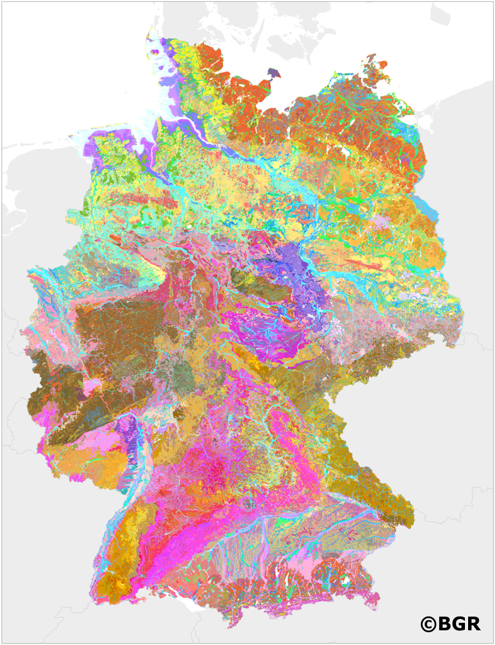
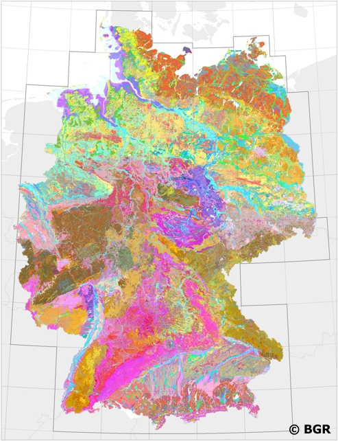
Soils can be classified according to important and typical soil characteristics. Such a fundamental property is the composition of the soil or soil type. The soil type describes the size of the mineral particles from which a soil is built. The content of organic matter in the upper soil determines how much water or how much nutrients can be stored in the soil. The soil thickness describes the space under the earth's surface that can be rooted by plants. The theme maps of soil characteristics in Germany are based on the landuse stratified soil map of Germany 1:1,000,000 (BUEK1000N), more than 9000 quality-assured soil profiles of the federal states from a twenty-year period and on the land use dataset CORINE Landcover 2006 (UBA).
-
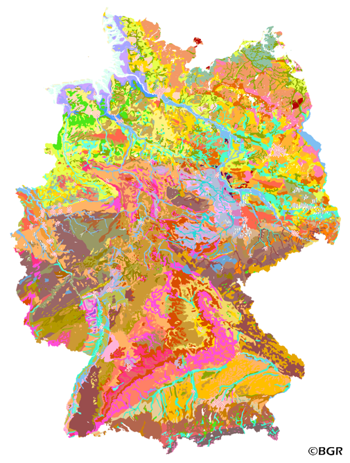
The Land use-stratified soil map of Germany at scale 1:1,000,000 (BUEK1000N), version 2.32, presents the distribution of soils and their associations nationwide in a uniform form at the aggregation level of the lead soil associations, which were intersected with 14 generalized and adjusted land use classes from CORINE Land Cover 1990. It did not appear as an analog map like the three subextracts of cropland, grassland, and forest. The digital map graphic is supplemented by climate regions, soil regions, and soil landscapes. The legend comprises 69 soil legend units with leading and accompanying soils (and information on the soil depth, the soil types, water conditions and the parent material), arranged according to soil distribution areas, partial legends arable land, grassland and forest, each subdivided according to climatic regions. The area-related content data are composed of 76 forest reference profiles, 78 cropland reference profiles, and 56 grassland reference profiles and are stored in a relational database. An additional 54-page booklet with explanations of the BUEK1000N can be purchased at GeoCenter Touristik Medienservice GmbH in 70565 Stuttgart, Germany, if required. The digital map graphics of version 2.32 are based on the topographic map of the Digital Landscape Model 1:1,000,000 (DLM1000) of the Federal Agency for Cartography and Geodesy from 2019.
-
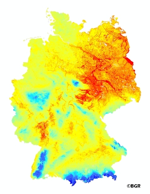
Web Map Service (WMS) of the mean annual rate of percolation from the soil in Germany (SWR1000). The mean annual rate of percolation from the soil is defined as the amount of water that leaves the soil after consideration of capillary rise. It is expressed in mm/a. Precipitation water infiltrated into the soil after deduction of surface runoff, first stands for the water supply of the vegetation available. Exceeds the water content in the root zone, the field capacity, the water infiltrated force of gravity moved following down and leaves the root zone. Movement of water in the unsaturated zone is affected by infiltration of precipitation and irrigation water, evaporation, absorption of water by plant roots, and ascent of water from the groundwater table by capillary action. The percolating water leaves the soil as interflow, discharging into surface water bodies, or via the groundwater table, recharging the groundwater. Percolating water affects soil formation and the migration and leaching of plant nutrients and contaminants. Knowledge of the rate of percolation is of particular importance for protecting groundwater quality. The mean annual rate of percolation is the balance of precipitation, evapotranspiration and surface runoff.
-
The soil map 1:250,000 (BUEK250) provides a detailed, nationwide uniform and comprehensive information base for statements on land use and soil protection across the states and Europe. It is based on BUEK200, which is prepared by the Federal Institute for Geosciences and Natural Resources (BGR) in cooperation with the National Geological Surveys (SGD) of the federal states in the sheet line system of the Topographic Map 1:200,000 (TUEK200) and published in 55 individual map sheets. The soil inventories and their spatial distribution are described in terms of individual legend units structured by soil regions and landscapes. Each legend unit contains soil systematic information as well as information about the soil parent material of each dominant and associated soil. The BUEK200 preliminary database can be downloaded free of charge via the BGR product center. The map is based on the Digital Landscape Model 1: 250,000 (DLM250) of the Federal Agency for Cartography and Geodesy (BKG) as of 31.12.2014 (2014_12_31_UTMGRS80, dlm250-aaa_ebenen). This includes the national territory of Germany, the tidal flats, sandbanks, the dike foreland and the coastal areas on the North Sea as well as the water bodies.
-
Web Map Service (WMS) of BUEK200 series. The soil map 1:200,000 (BUEK200) is prepared by the Federal Institute for Geosciences and Natural Resources (BGR) in cooperation with the National Geological Surveys (SGD) of the federal states in the sheet line system of the Topographic Map 1:200,000 (TUEK200) and is published in 55 individual map sheets. The digital data management provides a detailed, nationwide uniform and comprehensive information base for statements on land use and soil protection across the states. The soil inventories and their spatial distribution on the territory of each map sheet is currently described in terms of legend units structured by soil regions and landscapes. Each legend unit contains soil systematic information as well as information about the soil parent material of each dominant and associated soil.
-
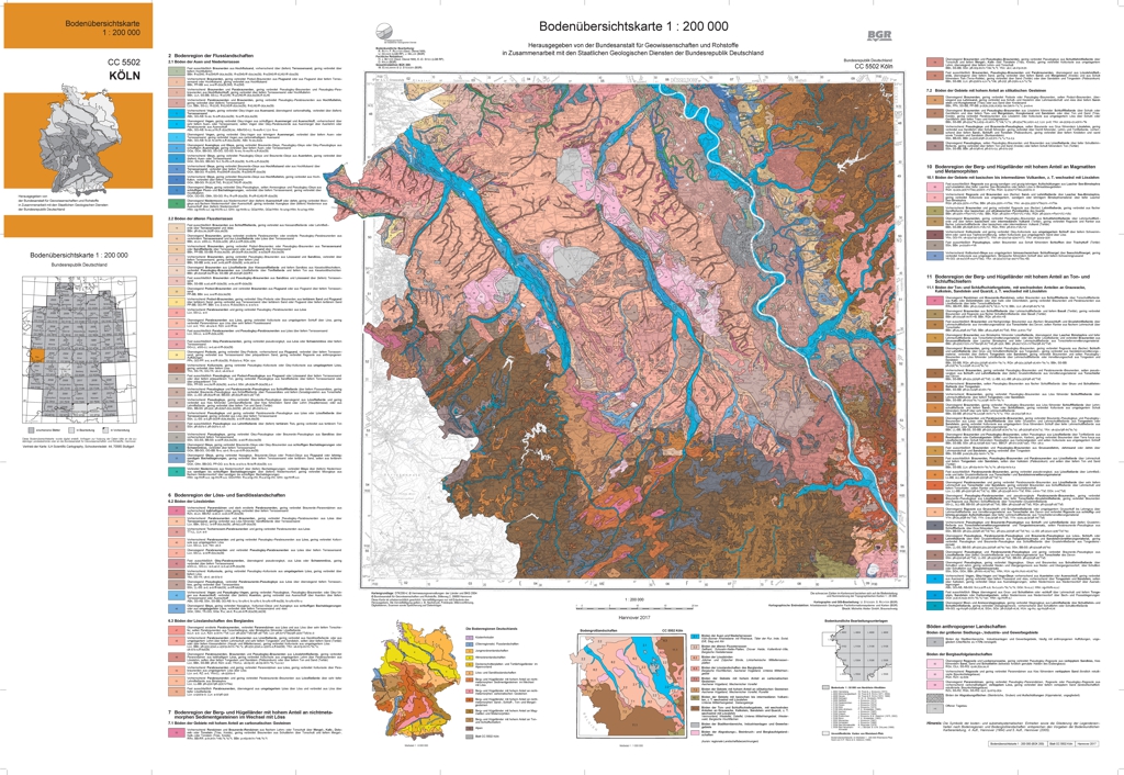
The soil map 1:200,000 (BUEK200) is prepared by the Federal Institute for Geosciences and Natural Resources (BGR) in cooperation with the National Geological Surveys (SGD) of the federal states in the sheet line system of the Topographic Map 1:200,000 (TUEK200) and is published in 55 individual map sheets. The digital data management provides a detailed, nationwide uniform and comprehensive information base for statements on land use and soil protection across the states. Information about the current state of processing can be found on the BGR website about soil. The soil inventories and their spatial distribution on the territory of this map sheet is described in terms of 96 legend units structured by soil regions and landscapes. Each legend unit contains soil systematic information as well as information about the soil parent material of each dominant and associated soil.
-
The Land use-stratified soil map of Germany 1:1,000,000 (BUEK1000N), Version 2.31, part cropland soils, was subdivided according to the main land cover types (forest, cropland and grassland) using the 1990 CORINE Land Cover data. However, it cannot be expected that the legend of this soil map is valid for the CORINE areas (in this project processed as vector data with the resolution of ca. 0,25 km2) rather than for larger patches (ca. 4 km2). Thus, the land cover data had to be generalized. The original land-cover classes were first aggregated into 14 combined classes, then generalized to at least 4 km2 patches, and finally intersected with the soil map units. The unchanged original soil map units were thus geometrically subdivided by land cover. Soil regions, soil landscapes and European climatic zones were also considered in order to stratify the legend of this new digital database. In another working step, the descriptions of the soil legend units were re-written in order to distinguish and to describe typical soil types and soil profiles under forest, cropland and grassland. For that, data from the BGR soil profile data base and from higher resolution soil maps as well as soil profiles from the national forest soil condition monitoring were evaluated. The results are stored in a relational database which is part of the BGR soil information system “FISBo BGR”. An additional, 54-page booklet with explanations for BUEK1000N can be purchased at the GeoCenter Touristik Medien Service GmbH in D-70565 Stuttgart.